
New Booklet: The 1841 Map
In the late 1830s the Bristol surveyor George Culley Ashmead (1801-1895) was commissioned to survey the parish of Bradford (then including Atworth, Holt, Limpley Stoke, South Wraxall and Winsley too) which was published in 1841. The survey was for the Tithe Apportionment, to determine who was liable to pay tithes (a tax) to the church. The tithes were to be commuted from goods...
Read More

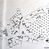
Holt in 1841
.
Holt, Bradford on Avon, Wiltshire
.
The old centre of Holt as mapped by the Bristol surveyor George Culley Ashmead in the late 1830s for the Tithe Apportionment of Bradford Parish. The elm tree on Ham Green was even then big enough to be marked. The woollen cloth factory buildings can be...
Read MoreDotesio’s Cycling and Rambling Map

Dotesio & Todd were printers and publishers with premises in Silver Street, Bradford and had acquired an outlet in Trowbridge as well. This map is entitled “Dotesio’s new touring, cycling, and rambling road map of forty miles about Bradford-on-Avon“. There is no date, but was...
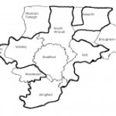
Read MoreBradford Manor Map
.
The area that was included in the Manor of Bradford that was given by King Æthelred II to Shaftesbury Abbey in 1001 is within the thick line. The dashed lines are the boundaries of the present parishes.
Click on the thumbnail picture for a bigger...
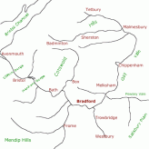
Read MoreTurnpike Roads of the Bradford Hundred
Click on the map for a larger version.
The roads of the Bradford Roads Trust are in red; other turnpike roads are in blue.
The first Bradford Road Act in 1752 authorised a Turnpike Trust to make, maintain and charge tolls on a road from Combe Bridge (at the boundary of Bradford with Monkton Combe, near the Viaduct) to Winsley, Bradford, Staverton...
Read MoreCanals to Bradford on Avon
Bradford on Avon, Wiltshire
.
The Kennet & Avon Canal through Bradford on Avon was fully opened in 1810, connecting the town to London in the east and Bristol to the west. The Somersetshire Coal Canal linked it to the North Somerset Coalfield and the Wilts & Berks Canal and North Wilts Canal gave easier access to...
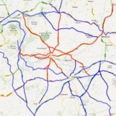
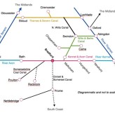
Read MoreA Bradford-centric railway map

Bradford was well-served by railways, but was not really the hub of the system! The map shows lines and stations, some still functioning, some swept away by the Beeching axe in the 1960s.
.
click on the map for a bigger...
Read MoreThe River Avon
Bradford’s river is generally distinguished from other Avons as the Bristol Avon. The name derives from Welsh afon, which simply means river.
Its course is unusual. It begins as several streams flowing east down the dip slope of the Cotswold Hills. They should really join the upper Thames, but the Avon turns to the SW following a vale cut in soft clay. Just above Bradford it...
Read More