Tollgates and Milestones
.
Bradford on Avon, Wiltshire.
.
The costs of making and keeping up the turnpike roads were financed by charging tolls for their use, with a scale of charges depending on the size of the individual vehicles and other traffic. It cost 1s 8d to drive a carriage to Bath in 1866.
Toll houses with gates were situated near the edges of the settlements; within the gates the upkeep of the roads was the responsibility of the parish. From 1839 the parish roads in Bradford were extended further from the centre, so some new toll houses had to be built further out. The Bradford quarryman-builder Charles Jones built new tollhouses at Forewoods Common on the Holt Road, Cumberwell on the Bath Road, Widbrook on the Trowbridge Road, Leigh and South Wraxall on the Corsham and Kingsdown roads and at Dainton’s Grave on the Frome road.
.
 Tolls were charged on the turnpike road between Cockhill, Trowbridge and Widbrook, Bradford. The Widbrook Tollhouse exists, now a private house with an added storey. Its projecting central section held the doorway for the keeper to attend the gate and charge tolls, now converted into window. This was built after 1839, when the town’s roads started to be supported by the rates alone. Before that tolls on the Trowbridge and Frome roads were charged from the road junction at Hall’s Almshouses.
.
.
 The post-1839 tollhouse on the turnpike from Bradford to Wingfield (and onward to Rode) also remains at Elms Cross, just up the hill from Sainsbury’s, where a branch goes off to Westwood village to join the earlier Trowbridge to Monkton Combe and Bath road.
.
.
.
 This building, which stood at the old junction of the Winsley and Bath Roads, looked like a tollhouse and stood where tolls on both roads could be charged. Previously a triangular tollhouse commanded three roads at Mount Pleasant. It became the Bath Road shop of Bradford on Avon Co-operative Society, but was demolished in the 1960s for road-widening.
.
.
.
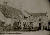 The old toll house where turnpike tolls were taken on the Bradford side of Holt. The turnpike gate can be seen on the right, while a board of charges was displayed on the wall of the house on the left. The former White Hart Inn, on the other side of the road, has been known as the Tollgate since about 1980.
.
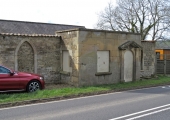 Another of the Bradford Roads Trust’s tollhouses still stands at the Bathford end of the 1792 Bath Road. The central projecting section of the original building stands just a few yards up from the junction of the Sally-in-the-Woods road with the lane to Warleigh, in Bathford, Somerset (grid reference ST7866466993).
.
 The Old Toll house at Atworth is where tolls were charged on the Bath to Melksham turnpike road, now the A365. It lies at the junction of the turnpike with the old village street, now Bradford Road.
.
.
.
.
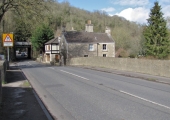 In Limpley Stoke, there was a tollhouse at the western side of Stokeford Bridge. Another was near the Rose & Crown pub, next to the Black Dog Turnpike (Warminster Road, A36).
Westwood had a tollgate near the New Inn, on the road from Trowbridge.
.
.
 The old toll bar on the Bradford side of the village of Turleigh which replaced a tollhouse in Newtown, Bradford. The gate is open and pushed back on the left, so the photograph is likely to date from after the abolition of tolls in 1873. Incidentally, the sign of the Prince of Wales pub can just be made out on the right.
.
.
Other turnpike tollgates in the Bradford Hundred were near the New Inn at Lower Westwood, on Forewoods Common where the roads to Holt and Staverton diverge, at Challeymead in Broughton Gifford where the tollhouse still causes a narrowing of the road that comes into Melksham, at Bradford Leigh, South Wraxall and Wingfield.
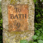
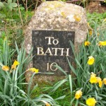
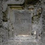 The roads of the Bradford Turnpike Trust were marked at intervals of a mile by milestones. Three cast iron markers are still in place giving distances to Bath: one (8 miles) is on the wall of the Priory in Market Street; the next (9 miles) is on a milestone at Widbrook (ST8333559838) and the 10-mile marker was on a milestone at Trowle Common (ST8426458593), but this one has now disappeared, removed or stolen. Milestones 4, 9 and 10 are Grade II listed buildings; 8 is part of the listed wall of The Priory.
.
.
.
.
.
.
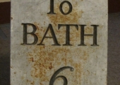 The milestone in the dip between Cumberwell and Farleigh Wick on the A363 Bath Road (at ST8117463553) is also missing its plate, but this has been found and given to Bradford on Avon Museum, where it can be seen.
.
.
.
Other milestones have gone missing, or their remains may be hidden in undergrowth at the roadside. That marking 7 miles to Bath was at Frankleigh, but has gone; the 5 mile stone still stands at Dry Arch near the county border, but its plate is missing.
 The milestone marking 4 miles to Bath (and 4 miles to Bradford) on the Sally-in-the Woods road above Bathford is still in position and its plate is in place.
.
.
.
There was another opposite the cemetery on Holt Road (8 miles from Bath) and 9 miles was marked on the road from Forewoods Common to Staverton Bridge. The Old Milestone Nursery beyond Holt on the road to Melksham commemorates another.


