.
The Limpley Stoke Valley
Bradford on Avon, Wiltshire
.

The Avon valley above Avoncliff, from Upper Westwood
The River Avon has cut a deep trench through the southern end of the Cotswold Hills, that winds between Bradford on Avon and Bath. It is almost gorge-like in places, especially the narrowest part, at Limpley Stoke. The Avon is joined by the River Frome and the Cam or Midford Brook, both in their own deep valleys.
The rocks it has cut through are limestones and calcareous mudstones that were laid down in the middle of the Jurassic Period, around 170 million years ago. At its deepest point in our area it reaches down to soft Midford Sand and Upper Lias clay of the Early Jurassic.
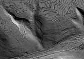
The weight of the limestones in the upper part has caused the soft strata below to be squeezed. This results in cambering, fracturing and slippage, in places at the top, causing opening of cracks, called gulls. Landslips are also a distinctive feature of the valley sides.
The steep sides and instability has made agriculture difficult in many places, so these are mostly covered by dense woodland. Where wood has been cleared, landslips are smoothed and the fields are used for grazing animals, although there are also signs of ancient field boundaries.
Good building stone has been exploited on the edge of the valley. The industry expanded after the Kennet & Avon Canal was built at the end of the 18th and beginning of the 19th centuries to carry Bath Stone to wider markets. Blocks of stone reached the canal by steeply-inclined tramways at Murhill and Conkwell in Winsley and at Avoncliff in Westwood.


