.
The Bradford on Avon Museum LiDAR Survey
A high-tech survey of part of the Bradford on Avon Hundred area, Wiltshire
.
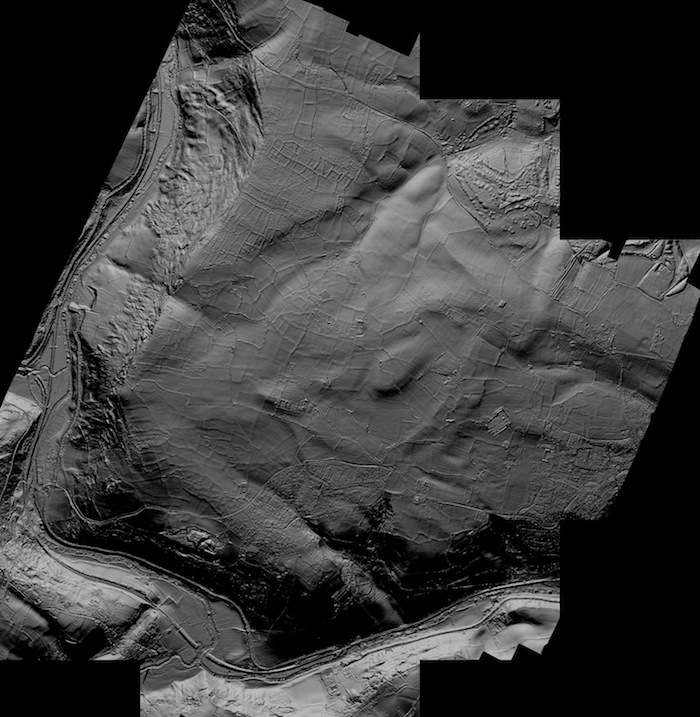
The LiDAR ‘image’ of the complete area of the Bradford on Avon Museum survey project ©
In 2012 Bradford on Avon Museum was awarded a grant by the Heritage Lottery Fund to use a then fairly new technology to carry out a survey of part of the area to the west of the town that could provide a very detailed aerial view of the ground, even in heavily wooded land. We knew that there were traces of past occupation of the land because ‘lumps and bumps’ could be seen on the ground and from aerial photography.
The project, called Ancient Landscapes, employed LiDAR (laser detection and ranging) technology by which a series of laser beam bursts is fired downwards from a plane that tracks across the country. The reflection of the laser bursts was recorded and the minute difference in the time it takes to arrive (at the speed of light!) gives a digital model of the ground that distinguishes between heights of only 100mm. The laser beam can even reach to the ground through the canopy of trees, but works best when there are no leaves, so the survey was done in winter at the beginning of 2013.
When the digital information is processed, the result is a picture of the area that shows a pattern of ancient field boundaries, many of which have been almost completely ploughed away and would not be known otherwise and others that are hidden in deep woods. Some of these boundaries, especially long linear features, may date back to the Bronze Age. Also to be seen are details of the geomorphology -the shape of the land itself, including landslips and watercourses.
It is hoped that investigations from old maps and other documents and on the ground will give more information about the age of the features the survey revealed.
The area surveyed covers the whole of the parish of Winsley and parts of Bradford on Avon, Monkton Farleigh, Westwood and Limpley Stoke, with incidental glimpses of part of Freshford, Monkton Combe, Bathford and Claverton in Somerset.
Find out more about the use of LiDAR in archaeology from English Heritage (opens in a new tab)
An interesting use of LiDAR in Central American archaeology in The Guardian (opens in a new tab)
- Animated 3-D video of Ancient Landscapes LiDAR (YouTube, opens a new tab)


