Explore the Kennet & Avon Canal
Bradford on Avon & Holt & Westwood & Winsley, Wiltshire
.
The River Avon was canalised between Bath and Bristol in 1727, while to the east, the River Kennet Navigation from Newbury to the confluence with the River Thames at Reading had been made in 1723. The construction of a canal between the two to give a through route from London to Bristol, avoiding a long dangerous sea voyage was proposed in 1788 and an Act of Parliament to allow it was passed in 1793. The first sod of the canal was cut in Bradford in the following year.
The competition, in the form of the Great Western Railway, purchased the canal in 1852 and its peak of prosperity passed. By the 1950s travel along it was difficult and in 1954 the stretch west of Bradford, always difficult to maintain, was drained. The Kennet & Avon Canal Trust was formed in 1962 and a slow process of restoration began, culminating in the Queen re-opening it in 1990. It is now a busy waterway for leisure craft.
> A timeline of the canal’s history
The canal in the Hundred of Bradford
 Coming from the east, the Biss Aqueduct is the first of the three aqueducts within the area and is similar in design, although the smallest of the three designed by John Rennie in the 1790s. Much of the facing stone has decayed and been replaced by brickwork. It carries the canal over the small River Biss not far from its confluence with the River Avon.
.
 Going westwards, the canal lies on an embankment above the River Avon and is lined by tall Lombardy poplar trees. At Widbrook is Bradford Marina, which was constructed in the 1980s and has services and moorings for 100 boats and a restaurant-pub called the Beef & Barge. It was in this area that there would have been a junction with the Dorset & Somerset Canal, had it been finished.
.
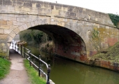
 Widbrook canal bridge (No. 170) carries Trowbridge Road over the canal. It must have been built in the 1790s, because the first part of the Kennet & Avon Canal, including a 31-foot deep cutting, was dug here in 1795. It was presumably designed, like the other structures along the canal, by John Rennie (1761-1821). It has been patched up with brick where the stonework has failed. A separate footbridge added, because it is rather narrow for modern traffic.
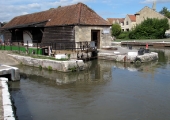
 Where the canal reaches Frome Road it drops in level by a lock for the first time from Semington. Here are Bradford Wharves, Upper and Lower.
> Bradford Canal Lock and Wharves
.
.
Below the lock and Frome Road Bridge, the canal is another long pound, a stretch without locks, all the way to the Top Lock of the flight down to the river in Bath. It passes through the scenic narrow Limpley Stoke Valley and crosses the River Avon twice by imposing aqueducts.
 The next major structure on the canal is Avoncliff Aqueduct, which carries it across the river. The architect-engineer John Rennie seems to have overestimated the strength of the long central arch, which sags a little, or the contractor cut corners in its construction. The facing stone has not weathered well and parts have been replaced with yellow brick or new stone. When restored in the 1980s a reinforced concrete trough was made in the acqueduct to carry the canal. A wharf on the southern side handled building stone brought by a tramway from Westwood Quarry.
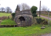
 Elbow Bridge, so called because it leads to a sharp turn on the course of the river below Winsley, carries a lane that gave access for the farmer to the fields beyond the canal. Today it is most used by water company vehicles servicing Winsley’s sewage works. The underside of the arch has had to be repaired using the GWR’s dark engineering bricks.
.
 The canal widens under the steep slope of Murhill. Murhill Wharf was built to handle blocks of stone that were brought down the hill by an inclined tramway, some sections of which are still in place, although buried. A crane would have loaded the stone on barges for export to Bristol or even to London.
.
.
 At intervals along this section of the canal were stop gates that could be closed to retain water when, as often happened, a breach opened and drained part of the canal. The canal was closed frequently to repair the bed and the gates were backed up by building temporary dams with heavy planks of wood that slid into slots in the gate walls. This rack for stop-planks was made from old Avon & Gloucestershire Tramway rails.
.
 The next bridge, Winsley Hill Bridge (No. 175), of Rennie’s same standard design as the previous ones, takes the Winsley to Bath road (B3108) over the canal near the foot of the hill. A separate pedestrian footbridge alongside was proposed by Winsley and Limpley Stoke Parish Councils in February 2018, but the road footpath has been improved instead.
.
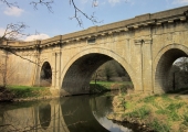
 The greatest structure on the Kennet & Avon Canal is the Dundas Aqueduct. It is 150 yards (137 m) long and of three arches- a round central arch of 64 feet (19.5 m) flanked by parabolic arches and all in Georgian doric style. It was named after Charles Lawrence Dundas MP (1771-1810), the first Chairman of the Kennet & Avon Canal Company, who has now become a place-name. He and the Superintendant of Works John Thomas (1752-1827) are recorded on plaques over the centre arch. The Somerset Coal Canal, of which a small stretch has been restored, joined the Kennet & Avon on the western side, in Monkton Combe, Somerset. From this point the Kennet & Avon Canal leaves the Bradford Hundred on its way to Bath.
.


