
.
Archaeological Survey at Rowley Deserted Medieval Village
Rowley, Farleigh Hungerford, Somerset
.
Having recently acquired Frobisher Resistance Meter archaeological geophysics equipment, with grant aid from the Bradford on Avon Area Board of Wiltshire Council, it was put to use in the summer of 2020 with ongoing research on the site of the deserted medieval village of Rowley (also known was Wittenham). The Rowley site is now in the parish of Farleigh Hungerford in Somerset, but until 1882 was part of the Hundred of Bradford on Avon in Wiltshire. It gradually became deserted after the Hungerford family acquired the manor and converted much of the land around into parkland.
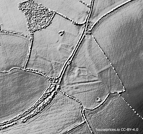 The site is marked by earthworks in fields on both sides of the lane between Westwood and Farleigh Hungerford. They can be seen on the ground and show well on aerial photographs and in a modern LiDAR survey carried out by the Environment Agency.
.
.
.
.
With relevant permissions in place, members of the Museum Research Group set out to make a resistivity survey to try to discover the whereabouts of the village’s church. Rowley had a parish church dedicated to St Nicholas, but it has completely disappeared.
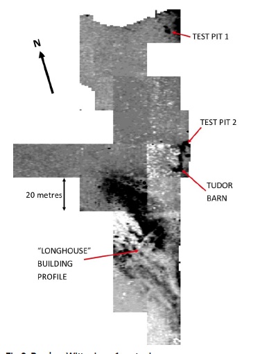
The field in question had already been surveyed two years ago using borrowed equipment with the normal 500mm probe spacing, which can look 500mm into the ground, but the Museum’s Frobisher equipment was ordered with a 1 metre probe bar option which measures down to 1 metre and it was felt that this would be a good site on which to try it out. This meant surveying 49 grids, which took five weeks in August and September.
Using the 1m bar gave some problems. If the ground is uneven, causing one probe to make contact later, this can produce a lower reading. To compensate, we angled the frame to make sure that the offending probe went in first. This, however, resulted in two severely bent probes. We had spares, the supplier sent replacements, and the problem was cured by adjusting the probe to stick out 12mm further. A pair of larger diameter “jumbo” probes are being made for us to use with the 1m bar in future.
The deeper view of the soil found the shape of a “longhouse” type building cutting into an area of high resistance and what is thought to be a Tudor barn, which were both visible on the first survey, but in addition there were two areas of high resistance (Test Pit 1 and 2) which did not appear on the first survey. They looked worth investigating further by making small excavations.
Test Pit 1 came down very quickly onto bedrock, but one find was a small piece of oolitic limestone, which had a right angle corner on it, indicating that it may have been dressed. The local stone here is shelly limestone, so this piece had been imported and is the only piece to have been found in the field. Did it come from the church? – further work is needed here.
Test Pit 2 found a jumble of large stones just below the surface, but none of them had been worked and they are almost certainly demolition material from the Tudor barn.
.
.
.
.
.
.

Test Pit 1 with bedrock in the upper part of the photograph

Test Pit 2’s rubble stones
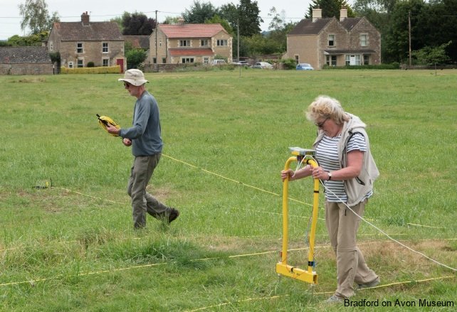
The Museum’s geophysics equipment in use on Broughton Gifford Common.
The probes are inserted into the ground at intervals following parallel lines marked by tapes across the survey area and they compare the electrical resistance of the soil with fixed probes. Places where the stones of walls exist under the ground tend to have a higher resistivity than organic soil-filled and damp pits and ditches.
.
.
.
Rob Arkell, Bradford on Avon Museum Research Group
.
.
.
.