.
Archaeological Research on Broughton Gifford Common
Broughton Gifford, Hundred of Bradford on Avon, Wiltshire
.
An intriguing collection of earthworks on Broughton Gifford Common have been interpreted as the traces of a former village that had been deserted in the Middle Ages, perhaps as the result of the ravages of the Black Death in the 1340s or a change from arable farming to rearing sheep.
 The earthworks are visible on the ground and even more so from the air and in modern LiDAR surveying.
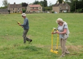
Bradford on Avon Museum has purchased, with grant assistance from the Bradford Area Board, a set of Frobisher Resistance Meter geophysics equipment and Museum’s Research Group put it to use to find out more about the Common.
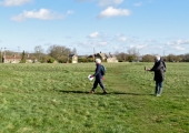
So, members of the Research Group spent a very pleasant morning in mid-March 2020 to get a feeling for the place. The sight of people with clipboards soon brought residents from their homes to see what we were up to. Once we explained that we weren’t planning to build anything, they were only too keen to tell us that the Common was used as a vehicle depot during World War II. The army delighted in driving through the many ponds and put up poles to deter enemy planes from landing. In the 1960s the Common became a dumping ground for old cars, some of them were buried there. When mains water and drainage were put in after the war the parish Council agreed that the spoil could be dumped in the ponds, one of which was subsequently re-dug in a slightly different place. None of this really accounted for the pattern of ridges and hollows.
The Parish Council was enthusiastic about the Museum carrying out a resistance survey with its new equipment, but by then the country had gone into the Covid-19 pandemic lockdown for three months. When restrictions were lifted the grass was waist-high and we had to wait until it had been cut as hay before beginning.
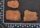
 An area of 100 square metres was surveyed, later expanded to 120 x 100 m, carried out over eight mornings in July and August. This produced a plot (left) in which some features matched those in the lidar image and others were intersecting lines of footpaths that had locally compressed the soil. One feature, outlined in red, did not show on lidar, but was parallel to an earthwork bank. The Parish Council gave permission for three test pits to be dug (and filled in again on the same day) in places with good potential. Instead of the abundant medieval pottery that would be expected if this really had been a deserted medieval village, the excavation only found three very worn pieces of pottery -and they were Roman! In the same pit was a small piece of Pennant Sandstone, a rock that was used in roofing Roman buildings, but has been much employed for paving in more recent centuries. Pit 2 was found to be waterlogged soil, which accounted for the patch of low electrical resistance and provided one piece of pottery that has not yet been identified. Pit 3 provided a little charcoal.
The conclusion seems to be that, because of the absence of pottery of the period, of which should we have had in buckets-full, the earthworks do not belong to a deserted medieval village site. Perhaps what we are seeing is a Roman field system that has been fossilised because the Common has never been ploughed. However, three sherds and a piece of stone are not enough evidence for a Roman settlement, as Roman pottery tends to have been scattered widely.


