What is LIDAR?
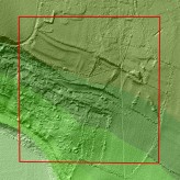
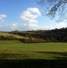
…and why are we using it? Image copyright of Bradford on Avon Museum. LIDAR image and data kindly supplied by the Environment Agency, who are conducting the LIDAR survey for the Ancient Landscapes project.
LIDAR is still a fairly new surveying technique in the field of archaeology, but it was chosen for the...
Read MoreHow to Get Involved

We now have a list of tasks to give you a better idea of how you can get involved with this exciting project.
Roy Canham held an introductory session on Wednesday 27th February for all those who had already expressed an interest in being involved. He discussed the background to the project and gave us all a flavour of some...
Read MoreIntroduction to the Project
Ancient Landscapes of the Bradford Hundred is a new Museum project for 2013, funded by the Heritage Lottery Fund.
We will be studying and recording traces of the prehistoric and Romano-British landscape over an area of 12 square km stretching from the town towards Winsley and Monkton Farleigh.
Why did we choose this area to survey?From 2000 to 2003 the excavation of a...
Read MoreAncient Landscapes of the Bradford Hundred
Our second Community Dig of 2014 begins Monday 11th August, and we will update the Ancient Landscapes pages during the dig.
Read our Community Dig blog from Spring 2014.
Ancient Landscapes of the Bradford Hundred started as a Heritage Lottery funded Museum project in 2013, using ground-breaking LIDAR technology to survey an area of 12 square km stretching from the town towards Winsley and Monkton Farleigh.
Read more about the 2013 project in the blog, or in our publication A Land Through Time.

Recent Posts
Lidar exhibition moves to Chippenham
Museum Booklet: A Land Through Time
This is not the end, and watch the video!