Lidar exhibition moves to Chippenham
. The Museum’s exhibition about the Ancient Landscapes of Bradford project is now on display at the Wiltshire & Swindon History Centre.
The exhibition “A land through time” was held at Bradford on Avon Museum in November last year. Now it can be seen as a temporary exhibition in the entrance foyer of...
Read MoreMuseum Booklet: A Land Through Time
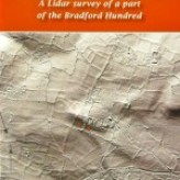
The eighth in the Museum’s series of booklets is a follow-up to our successful Heritage Lottery-funded LiDAR project. This measured tiny differences in height of the land surface of part of the Bradford Hundred area by the reflected beams of lasers fired from a plane.
It produced amazingly detailed images of large numbers of features in the landscape that have...
Read MoreThis is not the end, and watch the video!
Our HLF funded project on Ancient Landscapes of the Bradford Hundred was set to run for the whole of 2013. We’re at the end of the year, the project has been a great success, and we have some spectacular images of the 12 square km we have surveyed.
But this is not the end! We are planning further activities for 2014, so keep checking the blog.
In the meantime, view the...
Read MoreComplex of features near Bath Road, Bradford on Avon
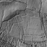
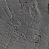
Following our two field-trips, Roy has been working on LIDAR images covering the complex of features near Bath Road. Image 1 shows that a more regular system appears to come through under extreme lighting from the east.
This is an amazing image considering that some of the features are only 4″ high.
...
Read MoreGill’s visit to the National Monuments Record in Swindon

Museum members visited Swindon in August this year with Roy Canham to look at some of the magnificent collection of aerial photos in the care of the National Monument Record Office. The purpose of the visit was to compare aerial photos from the Swindon collection with images produced by the Museum’s LIDAR project. These images had...
Read MoreRob’s Field Walk, Saturday 26th October 2013
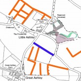
The weather was kind to us as we set off from St Lawrence School armed with plots of the LIDAR survey. We passed near the site of the Roman villa and were soon looking at our first ancient field which showed up as three sides of a rectangle, only one of which marries up with a tithe boundary. Our next point of interest was a possible...
Read MoreZooming Out
Entries on our blog so far have focused on areas of special interest, checking how data from the project may help us to understand how the landscape of Bradford Hundred may have developed over the last 3000 years.
It’s valuable to ‘zoom out’ and take a broader view. The image was processed in newly acquired software and...
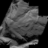
Read MoreSpectacular fields around Haugh Farm
Plotting of the ancient landscape detail from the Lidar survey is nearing completion. To aid this process, Ritchie Brown has produced 6 images from each kilometre square Lidar tile, each image processed from a different azimuth or compass point to show up archaeology from a range of lighting angles.
The results can be...
Read MoreThe Medieval Landscape Emerges
As work continues on plotting archaeology from the Lidar images, it’s clear that we will get a mapping of the prehistoric and Romano-British landscape. This was from the outset the main objective. There are now a few signs of a period in time that has defeated local archaeologists and historians, namely the form of the landscape since Domesday – Bradford Hundred in the Middle...
Read MoreMap plotting uncovers new secrets
The previous blog described how we produce high quality images from the LIDAR for use in the plotting process. Recording archaeology is very much a mapping process. You need to know what’s been found and where. So we have started the plotting process using a GIS (Geographical Information System) in which we can plot archaeology using Ordnance Survey digital mapping as a...
Read MoreSix Views Of Each Square Kilometre
One of our project team, Ritchie Brown, has developed some really superb methods for handling the Lidar data. Using a very complex Geographical Information System (GIS) called GRASS, he has produced high quality image files which reveal the surface detail in superb quality.
Click the images below to view larger versions
...
Read MoreCeltic Fields
The aim of our project is to use the LIDAR system to bring to light the ancient landscape around Bradford on Avon. Our best hope has been to recover the location and plan of early field-systems. As an example, photo A (top left) records a set of prehistoric fields on Chitterne Down, Salisbury Plain, which shows...
Read MoreInterpreting LIDAR data – it’s a question of light
Roy Canham reports on the importance of light:
Back in March Kate reported on the very rapid photographic survey we undertook right across the project area. The purpose was to record the condition of each field so that we had same measure of judging just what ground conditions were current at the time of the airborne LIDAR survey.
Click the photos below...
Read MoreShedding new light on our villages

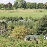
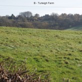
Our main aim in the Ancient Landscapes project is to use the LIDAR survey to reveal very early landscapes, some of it consisting of features dating from around 1000BC. But we are beginning to get detail of more recent patterns, in particular indications of settlements that have shrunken in size or changed shape. Winsley Church Farm,...
Read MoreInterpreting Air Photographs

On Wednesday 20th March, Roy and Sophie led an Aerial Photography workshop for volunteers on the Ancient Landscapes project. For those of you who aren’t actively involved with the project but like to keep up-to-date on its progress, here’s a brief explanation of how we will be using air photographs to supplement the LIDAR data.
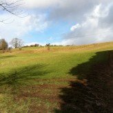
... Read MoreRoy’s woodland survey
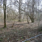
On 5th March Ritchie and I did a quick survey of woodlands in the project area. This photo shows a part of Inwood, with a section of the prehistoric field-system showing up as a low bank. It was good to see that under winter conditions some 80% of the sky is visible looking up through the trees, explaining why the test area for LIDAR...
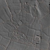
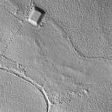
Read MoreInitial LIDAR Findings!
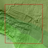
We now have some early results back from the LIDAR survey. We chose a couple of small areas within our 12 sq km to test the quality of the data we were getting back and we have been thrilled with the results. Here is an example.
The image shows an area south of Winsley. The land slopes down towards the River Avon – the...
Read MorePublic Talk: Ancient Landscapes of the Bradford Hundred
Wednesday 24th April, 7:30pm at Bradford on Avon Library
A public talk by Roy Canham, former County Archaeologist for Wiltshire, and leader of the Museum’s exciting new project ‘Ancient Landscapes of the Bradford Hundred’.
Tickets are £2.00 and can be purchased on the door.
Read MoreKate’s Field Checking Story
In order to help with interpreting the LIDAR survey results, it is important to know the state of each field at the time of the survey.
Our LIDAR flight took place on Friday 11th January, but within a few days the whole area was covered by snow making it impossible to conduct a survey of the state of each field. However, Roy...
Read MoreOuting to Cheverell Down

On 2nd February, Roy took a small group onto Cheverell Down, part of the Salisbury Plain Training area, to view the remains of a substantial ancient field-system. This was show persons interested in the project the kind of archaeology we are hoping to detect locally – though not so extensively preserved. This was a useful...
Read MoreAncient Landscapes of the Bradford Hundred
Our second Community Dig of 2014 begins Monday 11th August, and we will update the Ancient Landscapes pages during the dig.
Read our Community Dig blog from Spring 2014.
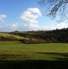
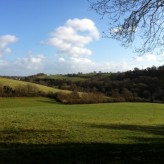
Ancient Landscapes of the Bradford Hundred started as a Heritage Lottery funded Museum project in 2013, using ground-breaking LIDAR technology to survey an area of 12 square km stretching from the town towards Winsley and Monkton Farleigh.
Read more about the 2013 project in the blog, or in our publication A Land Through Time.

Recent Posts
Lidar exhibition moves to Chippenham
Museum Booklet: A Land Through Time
This is not the end, and watch the video!