The Medieval Landscape Emerges
As work continues on plotting archaeology from the Lidar images, it’s clear that we will get a mapping of the prehistoric and Romano-British landscape. This was from the outset the main objective. There are now a few signs of a period in time that has defeated local archaeologists and historians, namely the form of the landscape since Domesday – Bradford Hundred in the Middle Ages.
In parts of Wiltshire strip fields or ‘ridge-and-furrow’ remain a clear indication of the social structure and agricultural of Medieval society, especially in the pasture areas of North Wiltshire where modern ploughing has been minimal. But around Bradford, this type of ancient field is hard to find, and we do not really know why since the town flourished at the time, no doubt under the influence of Shaftesbury Abbey at Barton Farm.

It’s something of a problem that we do not know why people went to such effort to create these elevated cultivation terraces – and we do not know what was grown on them! One theory is the strip lynchets were created after massive population increase and represent a need to cultivate marginal land. But more likely they had some special purpose, perhaps for raising a crop that needed good drainage and ventilation. Vines?
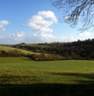
Such Medieval cultivation terraces existed close to the town – see the photo B (below left) looking across the Avon from above Greenland Mills, and of course there is the house called The Lynchets on the same slope. Photo C (below right) shows a similar system on the hillside above Greenland Mills, hidden beneath the trees, but actually known to locals as The Strips!


Click on any of the images to see a larger version
Get involved!

If you are interested in getting involved with this exciting project, please contact Roy Canham on 01225 866748 or at roycanham@btinternet.com.
If you’re not sure what you could do to help, read our How To Get Involved blog post.
If you aren’t able to help, but you want to keep up to date, then please follow our blog. We’ll be holding public talks and other events throughout the year, so look out for announcements here.
Ancient Landscapes of the Bradford Hundred
Our second Community Dig of 2014 begins Monday 11th August, and we will update the Ancient Landscapes pages during the dig.
Read our Community Dig blog from Spring 2014.
Ancient Landscapes of the Bradford Hundred started as a Heritage Lottery funded Museum project in 2013, using ground-breaking LIDAR technology to survey an area of 12 square km stretching from the town towards Winsley and Monkton Farleigh.
Read more about the 2013 project in the blog, or in our publication A Land Through Time.

Recent Posts
Lidar exhibition moves to Chippenham
Museum Booklet: A Land Through Time
This is not the end, and watch the video!